GeoWS Client Project Results
Introduction
For the past three months, IRIS DMC has been involved in an exciting project in collaboration with UNAVCO and MG&G/Lamont. Called GeoWS, this team has met biweekly via teleconference, working in a coordinated fashion to bring the three cross-discipline data sets into a single, integrated data presentation on the globe. (For more background on GeoWS at its inception, please refer to our last newsletter article, GeoWS: A Partnership for Interoperable Data Exchange).
Web Mapping Services
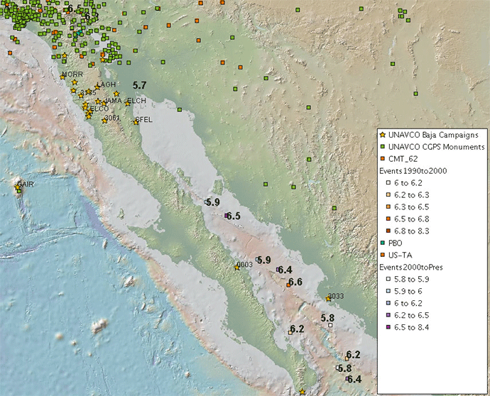
The goal was to have an effective demonstration ready by AGU, and we are proud to say that we are ready to show this off to scientists, students, and educators alike. What we have created is a catalog of readily available Web Mapping Services, following Open Geospatial Consortium (OGC) specifications, drawn from each of our three data centers. By following a standard protocol for sending and receiving XML messages via HTTP, we can use one of many freely available GIS tools for viewing and exploring these data sets in a geographic manner.In Fig. 1, we show an image of a site where land and water meet (Baja, Mexico). These are good candidate sites for demonstration because it brings both land based instruments and water bound ship expeditions.

This was generated using a freely available GIS client called uDig, which is based on the Eclipse Java toolkit. In the picture, you find the following contributions from each site:
- MG&G/Lamont – detailed bathymetry mosiac overlay with a standard topographic map set (ship track vectors not shown).
- UNAVCO – Baja campaign station siting, GPS monument siting, and Plate Boundary Observatory (PBO) siting.
- IRIS – Transportable Array station siting, large earthquakes with coloration by magnitude, CMT solutions for events greater than 6.2 magnitude (provided by SPADE).
Though you can’t tell by the article, this isn’t just a static image, this is a living, breathing, interactive map. You can click the points of interest to get detailed information about a station or earthquake. A URL included with the information allows you to go directly to that data center to learn more about it and even request data. Each of these data categories are ‘layers’ that can be turned on or off, depending on how much information you want to see on the map. You can grab the map and drag it to a different part of the globe, or use the zoom features to go in closer or pull out to a global view. The map is dynamically redrawn, gathering data from each of the GeoWS data centers, so you know you are working with the latest information.
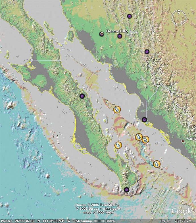
uDig is only one example of many clients that can access and display this data. Perhaps the most impressive, and most hailed mapping tool in use right now is Google Earth, and yes, the GeoWS servers can talk to Google Earth. Figure 2, shows the same site of interest, using the KML adapters built in to the GeoWS mapping services (fewer points are shown).

The GeoWS team will continue forward to expand the capabilities of the services and find new partners to bring into the circle of data integration and exposure of standardized Web Services. Be looking for us at AGU, where we will have live demos at the Earthscope, eGY, IRIS, MGDS, and UNAVCO booths. In addition, we have a poster session on Friday morning of AGU, submitted to session IN51A.
GeoWS has a website, which will be our home for publicly available information on who we are and how to reach our services. We are in the process of readying that information in time for AGU. Please check in to http://www.geows.org for updates on our project.

by Rob Casey (IRIS Data Management Center)


